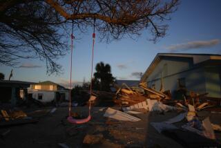
Hurricane Earl Lashes Florida Panhandle
- Share via
MIAMI — Schools and airports were closed, tourists went home and residents of Gulf Coast barrier islands were urged to flee inland as blustery Hurricane Earl sloshed ashore Wednesday over the Florida Panhandle.
With top winds estimated at 80 mph, the season’s fourth named storm was a welterweight as hurricanes go, with more potential to unleash flooding than to flatten homes. Satellite photos also showed that Earl was a poorly defined, lopsided storm, with almost all of its heavy weather to the east and north of its center.
Nonetheless, Earl lashed the Florida Gulf coast with heavy rains through the day and threatened to overwhelm low-lying and fragile barrier islands that are just inches above sea level. A storm surge of 8 feet above high tide and as much as 10 inches of rain are possible, forecasters said.
The ragged eye of Hurricane Earl was expected to pass over the coast early today near Panama City and move to the northeast. Although winds are likely to diminish, the storm is expected to spread heavy rains into Georgia and the Carolinas over the next two or three days, forecasters said.
“What we are really concerned about is the storm surge and tremendous rains,” said Gov. Lawton Chiles in declaring a state of emergency in three Panhandle counties. “Of course, if the storm did stall, it could intensify and become a much more dangerous storm.”
Tornado warnings were posted for several counties in north and central Florida.
Eglin Air Force Base sent 30 fighter jets to Oklahoma. Roads leading away from the coast were thick with traffic, and shoppers jammed stores to snatch up candles, batteries and bottled water.
At a Shell station on Panama City Beach, frantic customers bought $5,000 worth of supplies, including gasoline, bread, milk and water, doubling normal sales. But as night fell and the wind picked up, clerk Shirley Lee said business just died.
“It’s blowing and raining pretty good right now,” she said. “I guess everyone’s afraid to come out.”
Lee said station management canceled the third shift and ordered her to close at 10 p.m.
Although hurricane warnings were posted for 320 miles of coastline, from Pascagoula, Miss., to south of Tallahassee, the Florida capital, most evacuations were voluntary. Mandatory evacuations were ordered, however, for barrier island communities along Apalachee Bay.
“We’ve taken the awnings down and given our guests maps of the emergency routes out of town, in case mandatory evacuations are called for,” said Karen Terrell, marketing director for the 700-room Resort at Sandestin in Destin, Fla., as winds picked up and horizontal rains swept the area. With only 40% of the rooms occupied, Terrell said many resort employees have also been allowed to go home.
What had been a diffuse area of turbulent weather in the Gulf of Mexico gave birth first to Tropical Storm Earl, which grew to hurricane strength early Wednesday. National Hurricane Center forecasters had predicted the storm would make landfall west of New Orleans.
Evacuations in six coastal Louisiana parishes had begun Tuesday, shelters were opened in Louisiana and Alabama, and at least one Mississippi casino closed.
But on Wednesday Earl stalled, meandered and then veered toward Florida, leaving Louisiana and Mississippi largely in the clear.
“The sloppy nature of Earl’s center made us relocate the warnings,” said forecaster Chris Landsea at the National Hurricane Center in Miami. “But we’re hoping most people had time to prepare and get out of harm’s way. I hope there are no people right there on the beaches tonight.”
Residents of Florida’s Panhandle have had many reminders to take tropical storms seriously, most recently in October 1995 when Hurricane Opal hit the area with 115-mph winds blamed for 21 deaths and about $3 billion in damage.
Times researcher Lianne Hart in New Orleans contributed to this story.
HURRICANE PRIMER: A look at the sometimes-destructive storms. A5
More to Read
Sign up for Essential California
The most important California stories and recommendations in your inbox every morning.
You may occasionally receive promotional content from the Los Angeles Times.


