San Francisco Bay Area rattled by 4.5 earthquake, followed by more aftershocks

- Share via
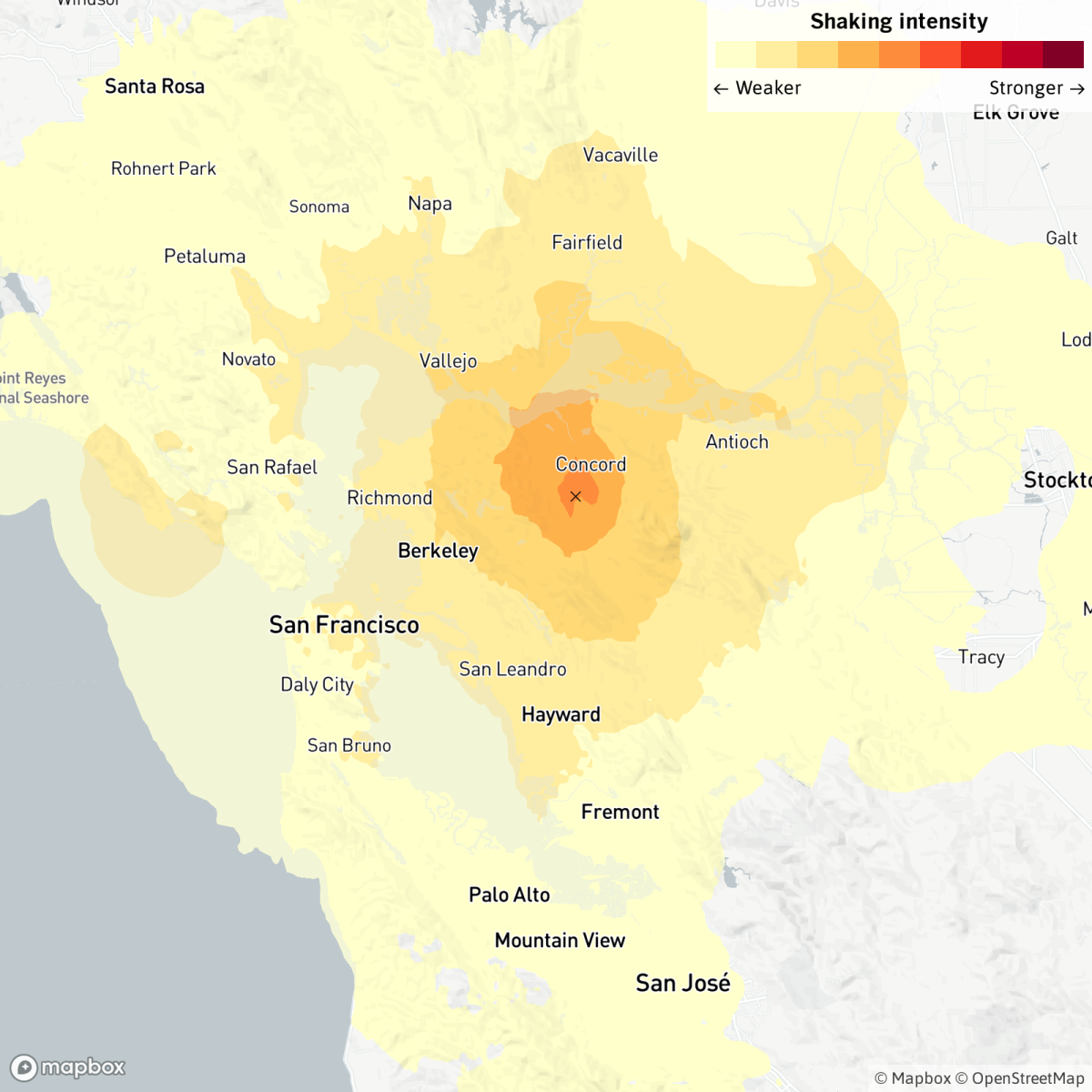
A magnitude 4.5 earthquake was felt widely in the San Francisco Bay Area at 10:33 p.m. Monday, with the epicenter in the Walnut Creek and Pleasant Hill areas.
Moderate shaking was felt in the Pleasant Hill, Walnut Creek and Concord areas, an intensity that can overturn unsecured objects, such as books and picture frames, and is capable of breaking dishes or windows. Weak shaking was felt in San Francisco, Oakland and San Jose, according to the U.S. Geological Survey.
Close to the epicenter in Walnut Creek, there was strong side-to-side shaking, strong enough to knock CDs off a shelf.
The USGS said there was a 2% chance of one or more aftershocks larger than magnitude 4.5 over the next week, and as many as four aftershocks of magnitude 3 or higher. “The number of aftershocks will drop off over time, but a large aftershock can increase the numbers again, temporarily,” the USGS said in its aftershock forecast.
Through the morning, there were several small afterschocks; the largest was 2.1 magnitude.
Based on the observed shaking intensity recorded by the USGS, scientists said they didn’t expect there to be major structural damage.
The earthquake had a preliminary depth of about 9 miles, fairly deep for this part of the world, Keith Knudsen, USGS geologist and deputy director of the agency’s Earthquake Science Center, said in an interview. The depth of the quake caused it to be felt over a broad area, but the shaking felt at the surface was less intense than if the quake had been more shallow, scientists said.
The earthquake was not directly on top of any of the main Bay Area earthquake faults. The epicenter was about three miles west of the Concord fault, and farther than that off the northern end of the northern Calaveras fault, Knudsen said.
The epicenter is just northwest of Mt. Diablo, one of the Bay Area’s tallest peaks. The Mt. Diablo area is also a seismically active zone, “a region of uplift, folding and thrusting,” said David Schwartz, USGS scientist emeritus.
There were a series of earthquakes in the magnitude 5 range on the southeast side of Mt. Diablo in 1980 in the Greenville fault area. On Jan. 26, 1980, a magnitude 5.4 quake hit with an epicenter only six miles from downtown Livermore. Damage in 1980 was reported at Lawrence Livermore National Laboratory and a mobile home park.
The Concord-Green Valley and Calaveras faults are among the Bay Area’s most significant.
Strong shaking from a hypothetical magnitude 6.8 earthquake on the Concord-Green Valley fault is capable of causing strong shaking in Contra Costa, Solano and Napa counties, and cause damage to the Kinder Morgan Concord pumping station, responsible for pumping fuel across the northern half of California, the Assn. of Bay Area Governments said in a report published in 2014.
The Calaveras fault can produce a quake in the magnitude 7 range, and it’s possible that it could rupture jointly with the Hayward fault, one of the nation’s most dangerous because the Hayward fault runs directly underneath densely populated cities in the East Bay, like Oakland, Berkeley, Hayward and Fremont.
Near the epicenter, it seemed the worst impact was residents shaken from sleep.
At Farrington’s Sports Bar in Pleasant Hill, about 20 patrons were playing pool and darts and watching TV when the earthquake started.
Bartender Casey Ashimine said no bottles broke but it was definitely apparent that they were experiencing an earthquake.
“A good little shaker,” Ashimine said. “A couple people looked around, but nobody freaked out.”
Assistant Chief Chris Bachman of the Contra Costa County Fire Protection District, which provides emergency services to communities close to the quake’s epicenter, said that as of about 11 p.m., there were no reports of injuries or property damage related to the earthquake.
The earthquake occurred just three days before the 30th anniversary of the magnitude 6.9 Loma Prieta earthquake, which killed 63 people in Northern California.
In the last 10 days, there have been two earthquakes of magnitude 3.0 or greater centered nearby.
An average of 25 earthquakes with magnitudes between 4.0 and 5.0 occur each year in California and Nevada, according to a recent three-year data sample.
Did you feel this earthquake? Consider reporting what you felt to the USGS.
Find out what to do before, and during, an earthquake by reading our five-step earthquake preparedness guide.
This story was originally generated by Quakebot, a computer application that monitors the latest earthquakes detected by the USGS. If you’re interested in learning more about the system, visit our list of frequently asked questions.
Times staff writer Mark Z. Barabak contributed to this report.
More to Read
Sign up for Essential California
The most important California stories and recommendations in your inbox every morning.
You may occasionally receive promotional content from the Los Angeles Times.


