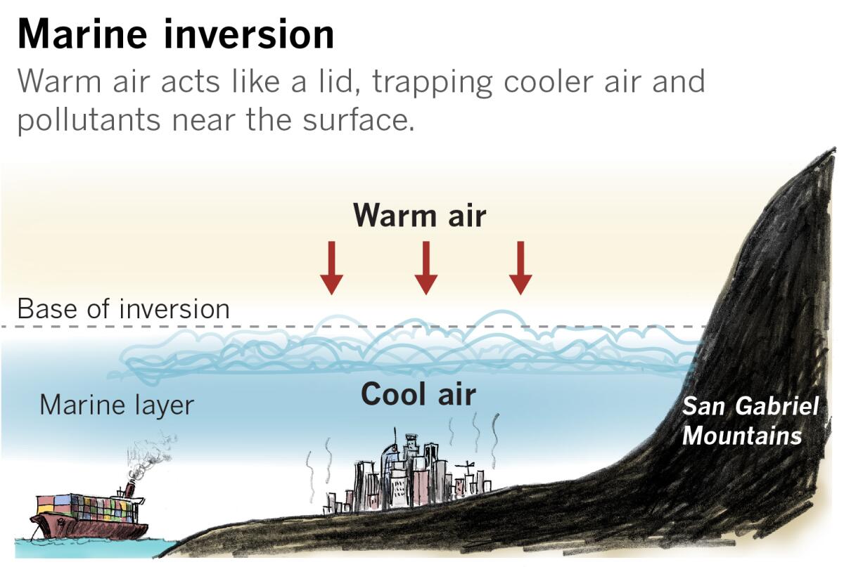
How a marine inversion over the L.A. Basin acted like a lid on a pot, trapping pollutants

- Share via
One good thing about Santa Ana winds: They really clear the air.
During the first weekend of November, a shroud of stagnant, hazy air draped the L.A. Basin, obscuring the local mountains and even downtown’s skyscrapers. Many Angelenos wondered what was causing it.
Air quality regulators blamed the poor visibility at least in part on weather conditions that trap air pollution over the region. But what weather conditions are the culprit?
“Definitely, we had a very shallow inversion for several days in a row,” said Eric Boldt, a meteorologist with the National Weather Service in Oxnard. “We had really dense fog and hazy skies. Nothing really cleaned that out until we had this offshore flow and our Santa Anas that started up in the last day,” he said Thursday. The inversion was several hundred feet off the ground, up to about 1,000 feet at the top, he said, and that was the reason for the fog and low visibility.
“It’s a marine inversion,” agreed David Sweet, another meteorologist with the weather service in Oxnard. He pointed out that the haze included fog and ocean air, and that the L.A. Basin is surrounded by mountains. So the ocean air comes in with onshore breezes, and is trapped by the surrounding mountains. The inversion then forms a lid on top of the basin.
How does an inversion work?
Inversions form when the layer of air close to the surface is cooled by the ground at night or by cold ocean water. The layer of air above it is warmer, and it acts like a lid, trapping the cooler air. The inversion layer can trap pollutants or smoke from wildfires along with the cool air.
The murky air can also limit the sun’s heating of the ground during the day, keeping the surface cool and perpetuating the process.
This scenario is common in Southern California in the spring and early summer, with the marine layer hanging over coastal areas for weeks at a time. The layer of air above the water is generally warmer than the water throughout all seasons, except for winter, thanks to the cold currents off the California coast. Usually, air would be expected to cool with increasing elevation above the surface. But the cold ocean water makes the air near it cooler than the layer of air hundreds of feet above it.
At this time of year, having dense fog for several days is kind of unusual, said Boldt.
A scenario that is perhaps more typical for this season would be the dry offshore flow of Southern California’s Santa Ana season — the kind of conditions L.A. is experiencing now. The winds do a great job of clearing the air and increasing visibility for many miles, and pollutants are pushed out to sea. But the winds also desiccate vegetation and create dangerous wildfire conditions.
Gusty northeast winds are expected to continue through early Friday, peaking Friday morning, the National Weather Service said. Unseasonably warm conditions and low humidity are expected to persist into the weekend, with elevated risk of rapid growth if a fire starts.
More to Read
Sign up for Essential California
The most important California stories and recommendations in your inbox every morning.
You may occasionally receive promotional content from the Los Angeles Times.


