A monster El Niño is likely, but there are ‘no guarantees’

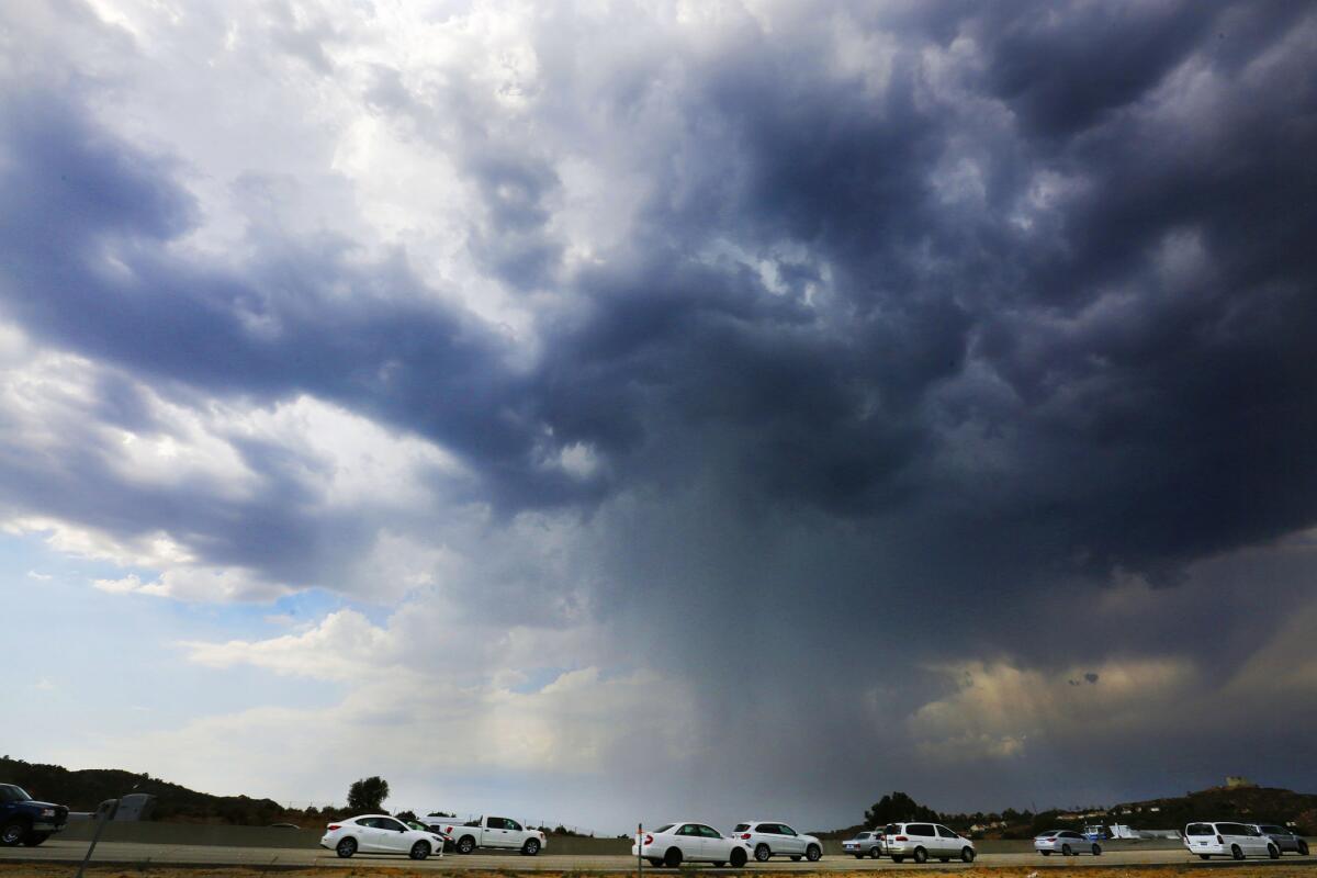
Cars move slowly along the northbound 14 freeway in the Santa Clarita area Wednesday as storm clouds and rain pass over the area.
- Share via
El Niño is on track to become one of the most powerful on record, strongly suggesting California could face heavy rainfall this winter, climate scientists say.
But El Niño still hasn’t sealed the deal, and there still needs to be a dramatic change in the winds in the Pacific Ocean if it is to be as strong as it might be, said Bill Patzert, climatologist for NASA’s Jet Propulsion Laboratory in La Cañada Flintridge.
“It’s still very impressive, but it’s a marathon with an El Niño,” Patzert said. “At 20 miles, do you hit the wall? Or do you pick up the pace?”
At this point, El Niño is strong and could be even stronger than the 1997-98 event, which brought heavy rain and deadly flooding and mudslides across California, and gave the south of the state double its rainfall and the mountains double the snowpack.
See the most-read stories this hour >>
The latest government El Niño forecast, issued by the National Weather Service’s Climate Prediction Center on Thursday morning, said that computer models unanimously favor a strong El Niño, and that there is a 95% chance that El Niño will continue through the winter -- essential if California is to benefit from increased rainfall as the state experiences its fourth year of punishing drought.
The Climate Prediction Center’s deputy director, Mike Halpert, said Thursday that sea-surface temperatures in a benchmark location of the Pacific Ocean are now exceeding 3.6 degrees Fahrenheit above the average. Those are the highest temperatures recorded “for the first time since the end of the 1997-98 El Niño.”
“The present El Niño is already one of the strongest on record and is expected to strengthen further through the late fall or early winter months,” said Daniel Swain, climate scientist with Stanford University, by email. “At this juncture, the likeliest outcome for California is a wetter-than-average winter.”
California could therefore receive stronger storms than typical, especially between December through March, Swain recently wrote in a blog post. And with sea temperatures particularly warm offshore, that could bring even more atmospheric moisture to fuel storm systems bound for this state.
“All of this suggests that there could be a substantially increased risk of precipitation-related hazards this winter in California, including flooding and landslides,” Swain wrote.
Even worse, the effects of the drought – deaths of trees and ash and debris left behind by wildfires – could increase the risk of mudslides and debris flow this winter.
California has already been feeling the effects of El Niño, with an increased number of hurricanes in the eastern Pacific that have sent intense storms over California this summer. El Niño is a factor in the rising humidity and scattered thunderstorms over the Southland this week, which have arrived from the remnants of Hurricane Linda.
Earlier this summer, storms that arrived from the remnants of Hurricane Dolores were so intense that floods knocked out an Interstate 10 bridge east of Palm Springs and dropped inches of hail on Interstate 80 near Lake Tahoe. El Niño is also believed to have influenced the heavy rains that produced flooding but ended drought conditions in Colorado, Texas and Oklahoma earlier this year.
“This El Niño is already happening and it’s already having impacts,” Patzert said, as warm ocean water from the western Pacific Ocean surges to the Americas.
But for this El Niño to rival the infamous “Godzilla El Niño” of 1997-98, as Patzert calls it, the east-to-west trade winds of the Pacific Ocean along the equator need to dramatically collapse, which would allow the sea near Peru to warm up even further. And that hasn’t happened yet, Patzert said.
“At this point, there’s no guarantees,” Patzert said. “I’m holding off on my apocalyptic rainfall forecast until I see what happens here in the next three months.”
The bottom line? “There’s still some drama here. The curtain has not fallen. We have not put this El Niño in the bank,” Patzert said. “I’m still pretty optimistic, but this is not signed, sealed and delivered. But we’re almost there.”
There has been extraordinary attention on El Niño’s development this summer, as many have saddled the weather phenomenon’s arrival with hopes of bringing relief to the punishing drought affecting much of the American West.
But El Niño can be hard to predict, and tracking it can feel like watching a soap opera, Patzert said, with each one taking different twists and turns.
One reason El Niño hasn’t sealed the deal now is that the trade winds are only slightly weaker than normal.
“My eyeballs are glued to what the trade winds are doing,” Patzert said. “We are still on track to have one of the strongest El Niños on record, but we could get derailed.”
Added Halpert: El Niño in “1997, from this point on, was really quite extraordinary, particularly in the low-level winds. And at least so far, we have not seen anything even resembling 1997 in the wind field over the last couple of weeks.”
Experts are also warning that while more rainfall would certainly be welcome, there is virtually no hope that one rainy winter could reverse the severe effects of the four-year drought. It would take years of above-average rain and snow to end the drought and refill empty reservoirs and wells, experts say.
“Californians should continue to use water carefully and sparingly in the face of the ongoing extreme drought,” state climatologist Michael L. Anderson said in a statement. “Californians should not count on El Niño to end the drought.”
Follow me on Twitter: @ronlin
Hoy: Léa esta historia en español
MORE ON WEIRD WEATHER
Thousands without power as extreme heat, powerful storms hit Southern California
‘Smog sieges’ often accompanied September heat from the 1950s to ‘80s
Ramona residents scorched and steamed over heat wave
More to Read
Sign up for Essential California
The most important California stories and recommendations in your inbox every morning.
You may occasionally receive promotional content from the Los Angeles Times.


