For farmers below the Oroville Reservoir, water still poses a threat
- Share via
Marysville, Calif., farmer Brad Foster stood at the eroded edge of the Feather River recently and contemplated how he was going to pull his water pumps out of the soggy, collapsed river bank.
“We’ll have to recover them somehow,” said Foster, 58, who owns about 500 acres of walnut orchards in Yuba County. “Those are stationary pumps. They’ve been there 50 years.”
In all his years of farming, Foster said he’d never seen such severe and widespread erosion along the winding waterway.
“This is not normal,” he said.
But little has been normal this year for folks in the Sacramento Valley — especially those people living in the shadow of the troubled Oroville Reservoir.
A record season of rain caused massive flooding throughout the region and triggered the evacuation of more than 100,000 people last month when the reservoir was damaged and overflowed. When California Department of Water Resources officials sharply reduced water flow into the Feather River to enable repair work, Foster and others were shocked to find that countless acres of riverfront property had been washed away.
Now, engineers plan to increase water flow into the river by more than 260% and some farmers and ranchers worry the influx will cause even more damage.
“My concern right now is erosion,” Foster said. “We have 100-year-old oak trees lying in the river. Everything that was there, old growth that protected the banks, it was just sucked in. … This is all going to go under water and it’s all freshly slipped material. This is all going to start eroding. We don’t know if it’s going to take the banks. … The river could actually start a new channel.”
Putting more water into the river now could send all that debris floating south, push more sediment into the river bed, raise water levels and trigger more erosion, officials in Sutter and Yuba counties say.
Friday’s release will be the first chance to see how the river behaves with a significant amount of water since so much of the banks eroded.
“When they see scouring, if it looks like its going to be directed toward a levee, that’s a concern,” said Chuck Smith, a spokesman for Sutter County. “So far this erosion has not imperiled the integrity of any levees.”
But it could be different if its combined with a spring or summer snow melt.
“If we get a warm rain, we’re going to be in deep [trouble],” said Dave Schmidl, superintendent of Levee District 9 in Sutter County.
There are 37 miles of levees on the east side of the river and 47 miles on the west side of the river, much of it reinforced, but not all of it. That’s why residents point to devastating storms in 1986 and 1997. During those floods, the water level within the river rose to more than 100 feet near Gridley and flowed at a rate of 150,000 cubic feet per second.
The river nearly reached that height last month and water lingered on levees for days. The river was at 89 feet on Feb. 27, the day that DWR engineers decided to temporarily plug the reservoir to make vital repairs to a power plant below it.
In less than two days, the Feather River at Gridley dropped 15 feet and slowed from 46,000 cubic feet per second to 2,500 cubic feet per second, turning a powerful river into a babbling creek.
According to locals and county officials, the state typically makes significant changes to river water flow over a period of days, affording farmers, fisherman and the river itself time to acclimate.
“The river actually acts as a support to the riverbanks,” said Phillip Filter, a third generation farmer in Live Oak. “When [the water] went down that fast, the support from the river itself just disappeared. It’s like applesauce; it just flows right in.”
After the shutoff, farmers in Yuba and Sutter counties reported river banks collapsing.
Foster said a 300-foot buffer zone of bluffs, trees and vegetation protecting his walnut orchard was wiped out and now the orchard sits in the path of future rising waters. Debris turned the river brown.
“I’ve never seen it so dirty in my life,” he said.
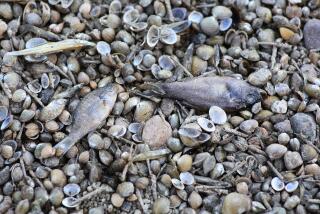
State wildlife officials said they pulled thousands of dead trout and salmon from the river in the days after the waters receded.
Farther south, a new sandbar cropped up Monday between two bridges connecting Yuba City to Marysville, Sutter County officials said.
Meridian farmer Jim Hafferty surveyed the river’s edges from land, water and the air over the weekend. It’s the scale of the erosion that’s staggering, he said.
“From the air, it’s just a whole different picture. It looks like there’s very little of the riverbank that didn’t receive significant damage from sloughing off,” he said.
But DWR officials said it’s unclear if their work at the reservoir was responsible.
“We’ve received over a year’s worth of rain in two months,” said Lauren Bisnett, a DWR spokeswoman. “It’s not uncommon to see erosion in that region.”
For breaking California news, follow @JosephSerna on Twitter.
More to Read
Sign up for Essential California
The most important California stories and recommendations in your inbox every morning.
You may occasionally receive promotional content from the Los Angeles Times.


