Massive Hollywood project sits atop quake fault, California says

- Share via
California’s state geologist has concluded that an active earthquake fault is underneath a massive proposed skyscraper project in Hollywood, setting the stage for a huge battle at City Hall over growth and seismic safety.
The California Geological Survey on Thursday released its final map showing the estimated path of the Hollywood fault. It shows the fault line running under Millennium Hollywood, which would be the tallest and largest development in Hollywood history.
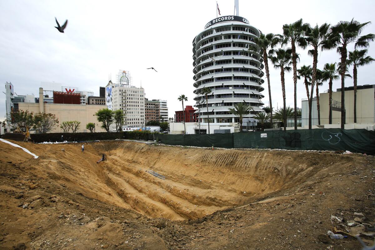
The state map shows a fault line south of the Capitol Records tower, an area that could serve as the site of one of the Millennium skyscrapers, according to conceptual sketches filed with the city.
“Our conclusion from the data is that there is an active fault, and it does run right along the course that’s right along the map,” state geologist John Parrish said.
The state’s findings further complicate the future of the project, which has the backing of L.A. Mayor Eric Garcetti and other elected city leaders.
Developers want to build 35- and 39-story buildings that would add 1 million square feet of housing, hotel rooms, offices, restaurants and stores, transforming land littered with parking lots into a new urban hub full of workers and shoppers in a project that could be worth as much as $1 billion.
The developer’s consultant, Michael Reader, again asserted Thursday that his analysis of his data shows no evidence of active faults underneath Millennium.
“We’re disappointed,” Reader said, adding that the state’s conclusion is “in our opinion, incorrect.”
Philip Aarons, of Millennium Partners, said in a statement that his company will continue geology testing to investigate any seismic safety concerns raised by the city. He said he believes more study will “further demonstrate our expert’s conclusions that no active fault exists on our site.”
“We’ve said it before and we’ve said it again: Millennium Hollywood is steadfast in its commitment to building a safe project that conforms to the highest earthquake resiliency standards,” Aarons said.
Because of the risk to public safety, California law generally bans new buildings on an active earthquake fault.
Houses sitting astride an earthquake fault have been split apart during the 1971 Sylmar earthquake and the Napa earthquake in August, rendering homes uninhabitable. In China and Taiwan, taller buildings on faults have been ripped apart, killing people inside when they collapsed, Parrish said.
It will ultimately be up to the Los Angeles Department of Building and Safety whether the project goes forward and permits can be issued to allow construction. The City Council voted last year to approve the Millennium project 13 to 0, but as concerns about seismic safety increased, Garcetti said he would rely on government experts to determine whether the city should issue permits to allow the skyscrapers to be built.
Jessica Levinson, a professor of law at Loyola Law School who focuses on governance issues, says the conflict between seismic safety and the desire for development puts the city in a dilemma.
“Common sense dictates that we need to be careful about building a skyscraper on top of a fault line,” Levinson said. “Ideally, this is the type of thing we do beforehand, where there is a determination about where it’s safe to build -- and then a project goes forward. And my gut feeling is that we may all learn from this experience.”
Millennium Hollywood has spent significant money on geotechnical studies after the state released a draft map in January showing the fault’s estimated path underneath its property. After a trench was dug on an eastern section of the Millennium site, Reader appealed to the state to remove the Hollywood fault from that area on the map.
State officials have analyzed all the data supplied by the developer’s consultants, but came to a dramatically different conclusion. Looking at a break in the soil layers at the southern end of a trench and underground sonar and soil samples, state officials said that an active earthquake fault slices through the part of the property where Millennium’s skyscrapers could be placed.
Los Angeles City Councilman Mitch O’Farrell, whose district includes Hollywood, said “there is clearly a disconnect between the [developer’s] data and the state’s final map, which must be reconciled.”
The state’s map now shifts the attention to city building officials, who judge whether a developer has proved a structure can be safely built away from an active fault.
The agency has several options: It could agree with the state’s conclusion and either ban construction or order a redesign that does not go over where the fault is. It could also order more study, or it could reject the state’s findings and allow construction to proceed.
Before it gets to that step, however, Millennium must submit its geology reports, which the developer said it will soon do. The data clearly show there is no active fault on the site, Reader said.
The city building department said it cannot make a conclusion until it receives and reviews the data.
“If an active fault is found, physically, not just theoretically, they’re going to have to deal with it,” said Luke Zamperini, spokesman for the Los Angeles building department.
There were other shifts of the estimated path of the fault line. The new map removes a line that went through the former KFWB studio site at 6230 Yucca St., where a 16-story residential complex is planned just east of the Millennium complex.
City officials last week agreed with the Yucca developer’s trench studies that no active fault is under the property.
A nearby commercial and residential development, known as Blvd6200, now has the fault’s estimated path skirting the northern edge of the development, instead of into the middle of it.
“We do not project the fault going underneath Blvd6200, but it certainly goes very close to it, through the backyard,” Parrish said. “They presented some persuasive information that the fault really should be pushed up north. We agreed with them.”
John M. Bowman, a lawyer for Blvd6200, praised the state’s decision. “The process worked,” he said. “A draft map was issued, extensive public comment was taken, and we participated in that public process.”
To the northeast, St. Stephen’s Episcopal Church no longer has an estimated fault path line running through it. On the official state map, a question mark appears, indicating that the state has additional uncertainty about the fault’s location in that area.
The California Geological Survey’s completion of the Hollywood fault zone marks a new era of restrictions for development in this thin zone, stretching from the Sunset Strip in West Hollywood to Atwater Village. Future construction in the fault zone will generally require proof that buildings won’t be built on top of a fault. The zone is roughly 500 feet wide on either side of the fault’s estimated path.
State scientists assembled the map over the last year by analyzing existing geology reports, including from old soil samples and geological formations that indicate the fault’s location.
“We have placed, I think with a great deal of accuracy and information, where we thoroughly believe that the trace of an active fault exists throughout this whole area,” Parrish said.
Opponents of the Millennium project said the city should halt the project. “This state map should be the final nail in the Millennium project’s coffin,” said lawyer Robert P. Silverstein, who represents neighborhood groups that have filed legal action against the developer and the city.
The existence of the Hollywood fault, which could produce a magnitude 7 earthquake, has been known for many decades, but it is less prominent than others that have erupted in recent times, such as the Newport-Inglewood and San Andreas faults. The Hollywood and the neighboring Santa Monica fault were closely mapped by geologists in the 1990s.
Parrish has said it is prudent to ensure buildings are not built on top of faults, but that hasn’t always been ordered by city building departments in fault areas that haven’t yet been zoned by the state. In December, the Los Angeles Times reported that more than a dozen construction projects were approved on or near the Hollywood and Santa Monica faults in the last decade without requiring seismic studies to determine if the buildings could be on top of an earthquake fault.
Building records show that when Los Angeles approved these projects, officials used outdated information that placed the faults much farther away from the developments. Last year, The Times reported that L.A. officials admitted that they didn’t realize their error until Times reporters pointed it out to them, and since then have been using more updated information available from the state.
One reason for the problem was the state’s failure for many years to create fault zones for the neighborhoods around the Hollywood or Santa Monica faults, a legacy of steep budget cuts that began in the 1990s that virtually halted mapping of so-called Alquist-Priolo Earthquake Fault Zones, named after the lawmakers who wrote the law.
Gov. Jerry Brown subsequently proposed a sharp increase in the earthquake fault mapping budget, funded by increased building permit fees, and signed it into law this year.
About 2,000 miles of faults still need to be zoned -- in places such as Los Angeles’ Westside, Orange County, Lake Tahoe, San Diego and the San Francisco Bay Area.
The state Thursday also released final maps for the Sierra Madre and Duarte faults in the northern San Gabriel Valley.
The budget boost has allowed the California Geological Survey to begin mapping the Santa Monica fault, which curves through the Westside and the city of Santa Monica. More detailed mapping of the West Napa fault, which was responsible for the magnitude 6.0 quake in August, is also expected to begin.
For more news on earthquake safety, follow us on Twitter: @ronlin and @RosannaXia.
More to Read
Sign up for Essential California
The most important California stories and recommendations in your inbox every morning.
You may occasionally receive promotional content from the Los Angeles Times.


