Washington’s Hazel Slide was a long-known risk

- Share via
ARLINGTON, Wash. — The Stillaguamish River and the Hazel Slide have been rivals for decades.
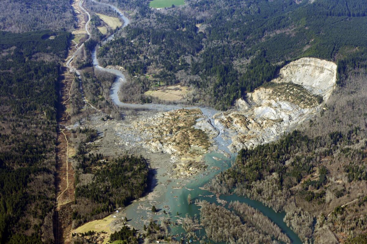
The river eats away at the clay and sand hillside to the north of the snaking river. Weakened by the erosion, the hill’s foot lacks the strength to fight the pull of gravity. Rain and logging add to the river’s offense.
In this deep-seated recess, landslides are inevitable. They send sediment surging into the river, deforming it for years until the cycle repeats.
DOCUMENTS: Warnings about landslides in Snohomish County
This ongoing battle exploded Saturday in a catastrophic geological event as a wall of mud, trees and rocks slammed into the river below, blocking the flow. This has happened before with the Hazel formation, mostly recently in 2006. This time, though, the slide kept going, surging onto the southern shore where it obliterated at least 49 homes, and everything in and around them. Sixteen people are confirmed dead and many more are still missing.
Even with today’s technology, Snohomish County officials and geological experts say they had no way to predict a major landslide.
“Each hazard is different,” Mark Stewart, a spokesman for Washington’s Emergency Management Division told the Los Angeles Times on Wednesday. “Obviously, this is the most significant landslide we’ve had in term of loss of life in recent memory.”
There have been numerous technical reports over the last several decades, however, that did warn about the weakness of the slope, which has lost its footing at least five times in the last 65 years. This knowledge has left some observers, including the authors of those reports, stunned about why people were allowed to reside in the area or why officials had not done more to protect them from the landslide.
Geomorphology consultant Daniel Miller studied the area for the U.S. Army Corps of Engineers in 1999 and found that the toe of the slope suffered constant erosion from the river.
In a separate report, he also determined that logging around the slope served as a catalyst for landslides because barren land left the ground saturated with water.
Miller recommended the slope be fortified — perhaps with rocks or a wall — or that the river be diverted farther away from the slope. If not, he concluded, there was an increasing “potential for a large catastrophic failure.”
In the months ahead of the 2006 landslide at the Hazel formation, the county had begun using logs and concrete blocks to keep the hill’s sediment from creeping into the river. The project was designed to protect fishes in the river, the Seattle Times reported this week. But the landslide thwarted the operation, leading to more extensive work in the years that followed, the county has said.
Millions of dollars were spent shoring up the area, the county’s Emergency Management Director John Pennington told reporters Wednesday. State and county officials, when contacted by The Times, couldn’t immediately provide an exact figure or detail the work.
Pennington said that the work done ensured small landslides from the timber-lined slope north of the river would be caught before it could damage the homes on the southern side of the river. Residents had felt protected.
“They knew the risk, but they felt safe in those smaller events,” Pennington said. “Sometimes, big events just happen. Sometimes, large events that nobody foresees happen. And this happened.”
In a 2010 report mandated by the Federal Emergency Management Agency, the county identified the Hazel formation as one that carried the potential for deep-seated landslides, considered the worst of the worst because of their power and size. Across Snohomish, nearly 5,000 structures and 14,000 people, or about 2% of the county, were exposed to such steep slopes.
In other studies, experts have called the slide “a chronic threat to fisheries” and a “persistent” threat to the river’s ecology. It seemed most vulnerable in the height of winter after a battering of rain.
Although officials said heavy rain may have played a role in Saturday’s slide, there also has been speculation about small earthquakes being felt in the weeks before. Scientists at the U.S. Geological Survey, however, have said that there was no earthquake the day of the landslide that triggered the slippage. But it remained possible, county officials said, that an earthquake of magnitude 1.1 on March 10 may be linked.
At least one person affected by the slide has said they had no idea about the risks despite the 2006 mudslide.
“Nobody told of any of us,” Robin Youngblood, 63, said Wednesday on CNN. Youngblood told The Times that she was covered in mud when a helicopter arrived to rescue her. She left with only a few belongings, including a Native American portrait, a nod to her heritage that she called “Night Warrior.”
In other cases, families of victims showed indifference to natural forces. “It’s just Mother Nature,” said Billie Spillers, who Wednesday was hoping authorities would find her uncle, Billy Lee Spillers.
A woman who has been living in a barn since evacuating the mudslide area said she is definitely returning to her home. “People say those people should have known and shouldn’t have bought there. Nobody could have known,” Nikki Behner told The Times.
Pennington said he would push geologists and other experts to determine what caused last week’s landslide, including whether an earthquake “shook it loose.”
“We did a great job of mitigating the impact of smaller slides coming in,” Pennington said. “I think we did what we could do.”
Dave reported from Los Angeles and Hennessy-Fiske from Arlington.
Follow LATimes National on Facebook
ALSO:
Judge strikes down Oklahoma’s execution law
Defense in Abu Ghaith trial says judge rushed jury, vows to appeal
White House offers extension on completing Obamacare enrollment
More to Read
Sign up for Essential California
The most important California stories and recommendations in your inbox every morning.
You may occasionally receive promotional content from the Los Angeles Times.


