Thick snowpack holds water — and potential peril
- Share via
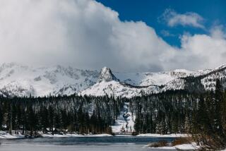
Reporting from Yosemite National Park — On a June day, Frank Gehrke and Vince White strapped on their cross-country skis and glided across the wintry landscape of Dana Meadows in Yosemite National Park. The surrounding peaks were wrapped in snow, the breeze crisp enough for a hat and gloves.
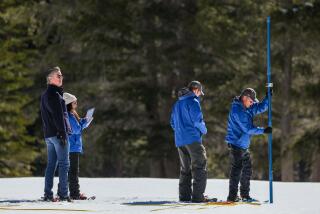
The men screwed together four sections of a hollow aluminum tube White had carried on his backpack. With a vigorous twisting of a handle attached to the cylinder, he drove it into the layers of snow. It didn’t hit dirt for another 7 feet.
After pulling up the snow-filled tube, White weighed it to gauge the water content. The Dana Meadows snowpack had enough water to form a 3-foot-deep lake.
Photos: Thick snowpack in West’s high country
From the Sierra Nevada and the Cascades to the northern Rockies, much of the West’s high country remains buried under a thick snowpack that is filling reservoirs and engaging dam operators in a nerve-racking balancing act as they watch for jumps in temperature that could turn all those scenic piles of white into raging floodwaters.
“It’s luck, but it’s also quite a bit of skill being applied,” state hydrologist Maury Roos said.
“We have staff trying to go through the records every day, asking, ‘What is this similar to?’ and it’s been extremely hard to draw a parallel to any other year,” said Jon Ericson, chief of hydrology for the California Department of Water Resources.
The first week of June in California, snow depths of 7 feet or more were not uncommon at high elevations. Sensors on Lower Lassen Peak in the Feather River watershed recorded a whopping 24 feet.
This year’s early spring snowpack in the Sierra was the fifth-largest in the last 60 years. A cool, cloudy May delayed its melt, and this month has been similar thus far — at some upper elevations, more snow has fallen.
California’s two largest reservoirs are nearly full: Lake Shasta, on the upper Sacramento River, and Lake Oroville, on the Feather River, a tributary of the Sacramento. Three years ago, in the middle of a statewide drought, Oroville was half empty.
Farther south, on the San Joaquin River, Friant Dam managers have partly drained Millerton reservoir to create room for the coming snowmelt, and they remain vigilant for potential flooding in such downriver towns as Firebaugh.
“Our issue is going to be temperature-driven. That’s what we’re going to be watching,” said Michael Jackson, a reclamation manager for South-Central California who is expecting nearly twice the average volume of runoff on the upper San Joaquin.
Federal and state dam operators consult every day with the Army Corps of Engineers. Once a week they hold a teleconference accompanied by a Web presentation to review the weather forecast, water demand and snow sensor results and see what “they expect to come down the hill,” Ericson said.
Barring a freak weather event, officials say, California should escape serious flooding.
Elsewhere in the West, the outlook is more worrisome. Spring rains have already caused flooding on the Missouri River as far south as Iowa, and much of the dense northern Rocky Mountain snowpack has yet to melt. “Any time from now on, folks need to be ready,” said hydrologist Kevin Low of the Missouri Basin River Forecast Center. “It’s not going to get any better for the next two or three months.”
The last dam on the river, Gavins Point on the South Dakota-Nebraska border, is making record releases.
In the upper Colorado River Basin, water managers are predicting the biggest flow into Lake Powell since 1997 — raising hopes that the Colorado’s stubborn drought may finally break.
Powell’s level is expected to rise 17 feet this year. The water level at Lake Mead, which is fed by Powell and supplies Las Vegas, Arizona and Southern California, is expected to climb 31 feet.
“While we’re not fully out of [the drought], we should be in good shape after this year,” said Rick Clayton, who coordinates releases from Powell for the U.S. Bureau of Reclamation. “It’s an exciting year for us.”
Scores of automatic snow sensors in the upper Colorado basin recorded the largest late May snowpack in several decades. “The second part of April, when we’d expect to get melt … we kept getting storms,” said Kevin Werner, a hydrologist with the Colorado Basin River Forecast Center.
If a days-long hot streak hits the Rockies, a rush of snowmelt could threaten Grand Junction on the upper Colorado and mountain resort towns such as Steamboat Springs and Aspen. Salt Lake City also could face floods from the melt in the Wasatch Range.
In most years, snow survey crews in California would have stowed the tubes used for manual sampling. But they were back in the field the first week of June, measuring the snowpack at about 30 locations to verify readings transmitted by automatic sensors.
Gehrke, chief of the California Cooperative Snow Surveys Program, and White, a hydrographer with Southern California Edison, parked at Yosemite’s Tioga Pass entrance, still closed for the winter season. Snow reached the roofline of the building next to the park’s massive brown gate.
The pair set off on skis, guided by a sketch of the snow course crews have measured in Dana Meadows every winter since 1926. About 20 minutes later, they arrived at an old pine with an orange sign marking the beginning of the course.
Gehrke, who has been taking snow surveys for 30 years, 24 of them for the state, checked a compass and the map. White glided ahead to scout for the other end of the 1,400-foot-long plot. Once oriented, they took out a measuring tape and every 200 feet stopped to drill the sampling tubes into the snow.
They checked the toothed end of the cylinder for dirt to make sure they had hit the ground and not just a crust of ice, recorded the snow depth in a log hanging from Gehrke’s neck and then weighed the snow core for water content. From that, hydrologists can calculate the volume of melt and runoff that nourish the state’s reservoirs and aqueducts.
“This manages water in California,” Gehrke said, holding up the simple scale that dangled from his ski pole handle.
The measurements at Dana Meadows didn’t break records. The water content was well below the 61.6 inches recorded in June 1983.
Still, Gehrke guessed it will be mid-July before the ground pokes through its winter blanket.
Photos: Thick snowpack in West’s high country
More to Read
Sign up for Essential California
The most important California stories and recommendations in your inbox every morning.
You may occasionally receive promotional content from the Los Angeles Times.


