Rediscover Kicks on Route 66
- Share via
Route 66, the 2,448-mile link between Middle America’s capital, Chicago, and the exotic West Coast, was commissioned 75 years ago this summer. And as the diamond anniversary of what author John Steinbeck called “the Mother Road” approaches, affection for the disintegrating ribbon of asphalt is growing.
There are Route 66 associations in each of the eight states through which it passes, as well as in Canada and Norway; Route 66 museums have been established in several states; and there is a long list of Route 66 celebrations to be held this year, from San Bernardino to Chicago, to commemorate a highway traveled by millions.
Efforts to restore the route, decommissioned by the federal government in 1985 and covered over in many places with the broad concrete lanes of interstate freeways, have been launched.
Supporters are urging a renewal of Route 66 tourism to breathe new life into restoration efforts in the towns and villages once joined by the road, also known as the Will Rogers Highway and, more fancifully, Main Street of America.
One bid to get Americans back on the Mother Road is being led by the Automobile Club of Southern California, which this week is releasing a Route 66 map that divides the trek into six road trips covering the most scenic and significant portions of the original route.
*
That route--which starts in downtown Chicago on the shore of Lake Michigan and ends at Ocean Avenue in Santa Monica, on the shore of the Pacific Ocean--started as a string of mostly gravel and dirt country roads.
They stretched from the top of Illinois down through Missouri, across the southeast corner of Kansas and through Oklahoma, the Texas Panhandle, New Mexico, Arizona and Southern California.
The highway brought Depression-era and Dust Bowl refugees to California by the tens of thousands in the 1930s, was a main artery for troops and materiel heading for the Pacific theater in World War II, and provided a colorful backdrop for billions of miles of vacation trips and millions of rolls of vacation pictures in the prosperous postwar years. That was before the interstate highway system bypassed most of the scenic areas in its mission to move the most the fastest.
Route 66 “was once a 2,400-mile carnival,” says David Knudson, co-founder of the National Historic Route 66 Foundation in Tujunga (https://www.national66.com). “There were all sorts of exciting things to draw you off the road. Everything from freak shows to lion heads to motorcycle races.”
Preservation efforts are aimed at “saving an important piece of Americana for generations to come,” he says, lamenting that “Route 66 is disappearing before your very eyes.”
When the federal government decided in 1926 to link all those separate state and county roads together as Route 66, only about 800 miles of it, or just one-third of the total, was paved. The rest of the asphalt was laid during the 1930s by road crews employed by the federal Works Progress Administration.
In California, their work included almost 400 miles of highway from Santa Monica to Needles. In the heavily populated Los Angles Basin and Inland Empire stretches, from the ocean to San Bernardino, the original road has been covered over, but stretches of several major surface streets, including Santa Monica Boulevard, Colorado Boulevard, Huntington Drive and Foothill Boulevard, follow its path.
Auto Club map writer Alan Rider skips over this section of Route 66 in his preface, commenting that it “has changed so dramatically over the years--and traveling it doesn’t provide the kind of experience that most old road travelers are seeking.”
So the 276-mile California Route 66 trip laid out by the Auto Club begins just past San Bernardino at the Cajon Pass Loop, a winding five-mile segment of old Route 66 that crosses the pass in a valley below Interstate 15.
From the end of the loop through Victorville, the freeway has wiped out the original route. But the trip picks up again on the National Trails Highways just out of Victorville and wanders through the Mojave Desert to Needles, across the Colorado River and into Kingman, Ariz., with only a few miles traveled on modern highways.
In Barstow, the largest city along the drive from Victorville to Needles, the Auto Club trip includes a stop at the Route 66 Mother Road Museum at 681 N. 1st Ave. The museum is housed in the 1911 hotel building, now called Casa del Desierto, that was the California flagship of the Harvey House hotel chain. The brick hotel also houses the Western American Railroad Museum.
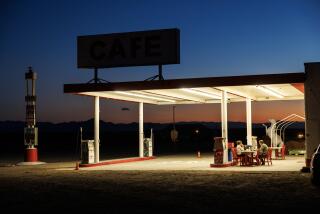
From Barstow, historic Route 66 traverses the Mojave to Newberry Springs (home of the Bagdad Cafe, made famous by the cult movie of the same name) and through the desert towns of Ludlow, Amboy, Essex and Goffs before hitting the Colorado River at Needles and crossing into Arizona as part of Interstate 40.
Just across the river at Topock, Ariz., historic Route 66 splits off I-40 and heads north through Oatman and then twists up and over Sitgreaves Pass and into Kingman.
The route is fairly well marked with Route 66 signs, but detailed traveling instructions can be found on several of the more than 60 Route 66-related Web sites on the Internet.
The Route 66 map is one in a series of annotated, plastic-laminated travel maps being published by the club and is available for $7.95 at specialty map and travel bookstores and selected Barnes & Noble bookstores throughout California. Auto Club of Southern California members get a special price of $4.95 in Auto Club offices and on the club’s Web site, https://www.aaa-calif.com.
*
Times staff writer John O’Dell can be reached at [email protected].
More to Read
Sign up for The Wild
We’ll help you find the best places to hike, bike and run, as well as the perfect silent spots for meditation and yoga.
You may occasionally receive promotional content from the Los Angeles Times.


