From the waves up
- Share via
“Don’t you drown! Just don’t you drown,” I think as icy Lake Tahoe surges into my lungs like a shock-freeze blast of inhaled Slurpee.
Pawing the water furiously and futilely, I look up to see lake bottom where the sky should be. A moment before, the kayak paddle rested on my lap as I closed my eyes, seduced by snowy peaks and the butterscotch scent of Jeffrey pines, glad to be free of whitecaps blasting out of Emerald Bay.
“Must get out!” But how? The advice of my paddling partner and guide flashes through my mind: Put your legs together, pull them up, kick to break the skirt seal of the kayak. I fight panic and perform each step, swoosh to the surface, gasp and live.
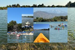
Others come to Tahoe to gamble or hike, snow ski or camp -- and depart thinking they know the lake. I came to paddle part of a newly mapped “water trail” along its 72-mile shoreline to understand the real Tahoe -- from bellybutton level. Adventure Maps’ new map -- one that includes hidden spots, campsites and a realm of nature accessible largely by liquid -- is the work of Bob Kingman, 41, a Lake Tahoe native and lifelong kayaker who has paddled the entire shoreline twice, once in just three days. A few years ago, Kingman took all his notes and, with research assistance from Dennis Liebl, wrote the guide.
Following the route and gliding quietly over the surface in a kayak offers a new perspective on the Sierra lake. But, as I learned, Kingman couldn’t control the wind-whipped conditions that turned the usually glassy lake into the Pacific. And I’m not prepared to paddle 72 miles; we would cover 6 1/2 miles in two days in boats stuffed with gear and food.
Day I
We launch at Baldwin Beach west of South Lake Tahoe at 9:30 a.m. under cotton clouds and a pastel sky. Clear water over tan sand yields to blue as we paddle northwest, hugging the shore. There’s hardly another soul on the lake.
Soon we hear the mild roar of Cascade Creek tumbling over boulders and into the lake. Just beyond it, amid a stand of tall pines, are the roofless remains of a cedar cottage where John Steinbeck spent the winter of ’26 writing the short story, “A Lady in Infra-Red,” which later became the novel “Cup of Gold.”
Aided by a tail wind, we paddle lazily in the shadow of gigantic ponderosa pines and red firs en route to Emerald Bay one mile north. The air is so clear I can distinguish individual trees on Mt. Rose 26 miles away. Near the shore, foot-long pine cones hang like lanterns from the dead branches of an ancient sugar pine, its needles dry and brown, the trunk gray-silver. Seeing these sights up close -- much closer than a motorboat would dare, given all the submerged boulders -- is why we paddle.
Eagle Point protrudes from the southern lip of Emerald Bay, and we don’t like what we see: 40 mph gusts and whitecaps streaming out of the bay. Kingman paddles hard as Liebl and I stay back. He makes it 50 yards, then returns.
“The bay is too rough,” he shouts. “It’s an accident waiting to happen.”
Indeed.
Instead of entering the bay, we make a 150-yard sprint across the mouth as waves broadside us. After a safe passage, I pause, rest and take my eyes off the water to glance at the bay. That’s when the kayak capsized.
Kingman races to me as I resurface. “Hold on to the kayak!” he shouts, as he pulls me near shore, where I crawl back into the boat.
We reach a secluded beach sheltered by trees and devour cheese and snacks. A family of Canada geese paddles in, followed by a fearless mallard, and they waddle up for a handout.
Fed, dry and regrouped, we shove off at 2:30 p.m. The whitecaps have subsided, so we attempt to enter Emerald Bay again for a close look at Eagle Falls, an enormous torrent of snowmelt tumbling over hundreds of rock slabs.
If ever a bay has been aptly named, it’s this green beauty. Forests flank the inlet, framed by jagged peaks with enormous snow bowls and vast granite faces. Eagle Falls and nearby tumbled talus resemble scars in the forest above the bay.
I pick up a trail through a boulder-strewn forest of pine and incense cedar and snow plants. Kingman and Liebl paddle toward the cascades, which like so many of the lake’s features, are best viewed from the water.
In waning daylight we pitch tents at Emerald Bay State Park Boat Camp. Fire warms us and sizzles filet mignon as smoke wafts through tall cedars where Steller’s jays watch from branches.
Day II
Honking geese, quacking ducks and a cacophony of birdsong greet the morning. Coffee and the hiss of Kingman’s gas stove fill the air. We munch a few bagels, then shove off shortly after dawn.
The shore north of Emerald Bay is unspoiled beauty. Chipmunks scamper over shattered trees, and red snow plants sprout amid fallen pine needles. Delicate pink flowers resembling raspberries peek from beneath shadowy shrubs.
The air is so warm that I pare down to a T-shirt and a splash jacket, though the lake is only 40 degrees. The water is so clear that pebbles are visible 25 feet below.
After 30 minutes of paddling, we discover two parallel falls erupting right out of the forest and spilling down the slope with a soft sound like tinkling glass. In a kayak you can get right into the splash zone, but you can’t do that in a powerboat because of sunken rocks.
We paddle toward Rubicon Point, over water 1,400 feet deep, one of the deeper parts of one of the nation’s deepest lakes, though we’re only a stone’s throw from shore. My borrowed kayak is narrow, so my feet are boxed in, and my legs begin to cramp and spasm. My feet jab the rudder controls, and the kayak gets tippy. I dread being trapped upside-down again, so I stop paddling and brace myself for a plunge.
Kingman sees my distress and shouts, “Paddle hard! Paddle hard!” The kayak heaves as I drive my paddle into swells, left, right, left, right, toward Lester Beach. “He was this close to capsizing,” Kingman says to Liebl, making a pinching gesture while we munch on salami and cheese at the beach.
I ask him if we’re going to round any more points.
“That one,” Kingman says, nodding toward a dark lip of land at the north end of Rubicon Bay, beyond which lies Meeks Bay, but we never make it that far. That night dark wind-driven clouds whooshed across a bright moon. Hours later it snowed, or as Kingman put it, “it dumped snow,” ending our trip.
*
For information on the Adventure Map of Lake Tahoe, go to www.adventuremaps.net.
*
Scott Doggett can be reached at [email protected].
More to Read
Sign up for The Wild
We’ll help you find the best places to hike, bike and run, as well as the perfect silent spots for meditation and yoga.
You may occasionally receive promotional content from the Los Angeles Times.


